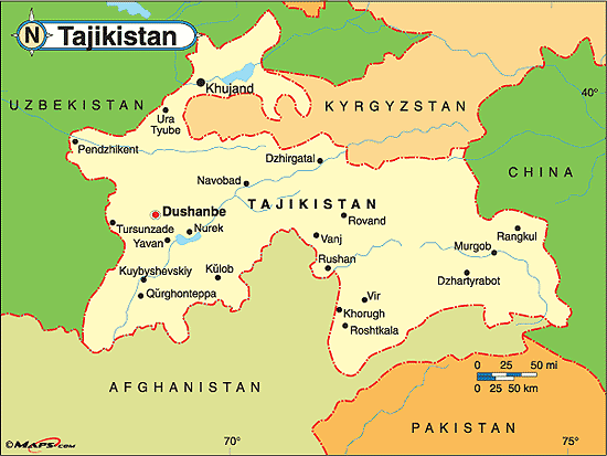
Tajikistan (itɑːˈdʒiːkᵻstɑːn/, /təˈdʒiːkᵻstæn/, or /tæˈdʒiːkiːstæn/; Persian: Тоҷикистон [tɔd͡ʒikɪsˈtɔn]), officially the Republic of Tajikistan (Persian Tajik: Ҷумҳурии Тоҷикистон, Çumhuriji Toçikiston/Jumhuriyi Tojikiston; Russian: Респу́блика Таджикистан, Respublika Tadzhikistan), is a mountainous, land locked country in Central Asia with an estimated 8 million people in 2013, and an area of 143,100 km2 (55,300 sq mi). It is bordered by Afghanistan to the south, Uzbekistan to the west, Kyrgyzstan to the north, and China to the east. Pakistan lies to the south, separated by the narrow Wakhan Corridor. Traditional homelands of Tajik people included present-day Tajikistan, Afghanistan and Uzbekistan.

Geography
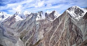
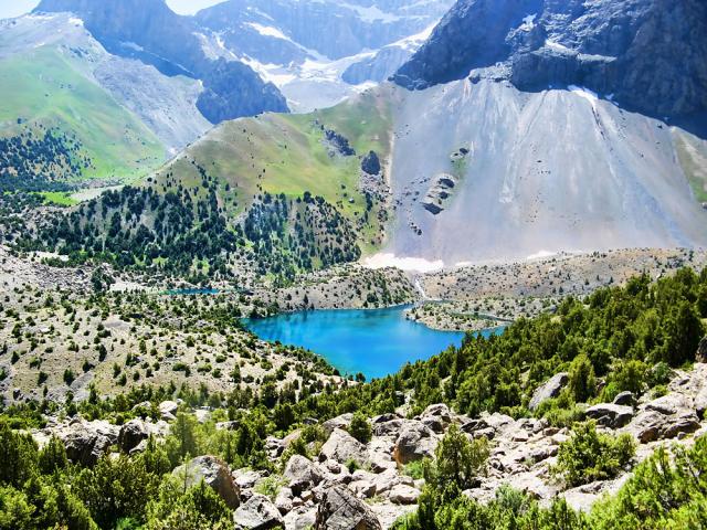
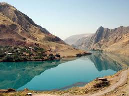
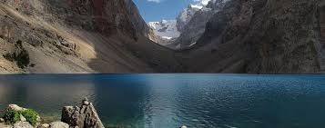
Tajikistan is nestled between Kyrgyzstan and Uzbekistan to the north and west, China to the east, and Afghanistan to the south. Mountains cover 93 percent of Tajikistans surface area. The two principal ranges, the Pamir Mountains and the Alay Mountains, give rise to many glacier-fed streams and rivers, which have been used to irrigate farmlands since ancient times. Central Asias other major mountain range, the Tian Shan, skirts northern Tajikistan. Mountainous terrain separates Tajikistans two population centers, which are in the lowlands of the southern and northern sections of the country.[1] Especially in areas of intensive agricultural and industrial activity, the Soviet Unions natural resource utilization policies left independent Tajikistan with a legacy of environmental problems.
With an area of 143,100 km2 (55,300 sq mi), Tajikistan has a maximum east-to-west extent is 700 km (430 mi), and its maximum north-to-south extent is 350 km (220 mi). The countrys highly irregular border is 3,651 km (2,269 mi) long, including 414 km (257 mi) along the Chinese border to the east and 1,206 km (749 mi) along the frontier with Afghanistan to the south. Most of the southern border with Afghanistan is set by the Amu Darya (darya is the Persian word for river) and its tributary the Panj River (Darya-ye Panj), which has headwaters in Afghanistan and Tajikistan. The other neighbors are the former Soviet republics of Uzbekistan (to the west and the north) and Kyrgyzstan (to the north)
Tajikistans climate is continental, subtropical, and semiarid, with some desert areas. The climate changes drastically according to elevation, however. The Fergana Valley and other lowlands are shielded by mountains from Arctic air masses, but temperatures in that region still drop below freezing for more than 100 days a year. In the subtropical southwestern lowlands, which have the highest average temperatures, the climate is arid, although some sections now are irrigated for farming. At Tajikistans lower elevations, the average temperature range is 23 to 30 °C (73.4 to 86.0 °F) in July and −1 to 3 °C (30.2 to 37.4 °F) in January. In the eastern Pamirs, the average July temperature is 5 to 10 °C (41 to 50 °F), and the average January temperature is −15 to −20 °C (5 to −4 °F).[6]
Tajikistan is the wettest of the Central Asian republics, with the average annual precipitation for the Kafiristan and Vakhsh valleys in the south being around 500 to 600 mm (19.7 to 23.6 in), and up to 1,500 mm (59.1 in) in the mountains. At the Fedchenko Glacier, as much as 223.6 cm (88.0 in) of snow falls each year. Only in the northern Fergana Valley and in the rain shadow areas of the eastern Pamirs is precipitation as low as in other parts of Central Asia: in the eastern Pamirs less than 100 mm (3.94 in) falls per year. Most precipitation occurs in the winter and spring.
The lower elevations of Tajikistan are divided into northern and southern regions by a complex of three mountain chains that constitute the westernmost extension of the massive Tian Shan system. Running essentially parallel from east to west, the chains are the Turkestan, Zeravshan (Zarafshan), and Hisor (Gissar) mountains. The last of these lies just north of the capital, Dushanbe, which is situated in west-central Tajikistan.
Population
Tajik Persian 89.9%,
Uzbek 8.5%,
Russian 1.1%
Kyrgyz 1.1%, other (including Pashtuns,
Bukharian Jews and Volga Germans) 2.6%
Total Population 8.208 million
Transport
Railways
The railroad system totals only 680 kilo metres (420 mi) of track, all of it 1,520 mm (4 ft 11 27⁄32 in) broad gauge. The principle segments are in the southwestern region and connect the capital with the industrial areas of the Gissar and Vakhsh valleys and with Uzbekistan, Turkmenistan, Kazakhstan and Russia. In 2000 a new line, theQurghonteppa – Kulyab railway, was completed and connected the Kulyab District with the central area of the country. Passenger transit through Tajikistan has been hindered by periodic failures of Tajik Railways to pay transit tariffs and by safety issues. Most international freight traffic is carried by train.
It is hoped that a 2009 agreement between the heads of state of Pakistan, Tajikistan, and Afghanistan will modernize parts of Tajikistans rail system to allow more trade between Central Asian countries.
Highways
The total length of roads in the country is 27,800 kilometers, nearly all of which were built before 1991. Automobiles account for more than 90% of the total volume of passenger transportation and more than 80% of domestic freight transportation.
As of 2014 many highway and tunnel construction projects are underway or have recently been completed. Major projects include rehabilitation of the Dushanbe – Chanak (Uzbek border), Dushanbe – Kulma (Chinese border), Kurgan-Tube – Nizhny Pyanj (Afghan border) highways and construction of tunnels under the mountain passes of Anzob, Shakhristan, Shar-Shar and Chormazak. These were supported by international donor countries. China has invested approximately $720 million for infrastructure improvements in Tajikistan, including the rebuilding, widening and improvement of the road between Dushanbe and Khujand which as of August 2007 is proceeding using equipment, labor, and oversight from China.
In mid-2005 construction began on a bridge across the Panj River to Afghanistan which was funded by the United States and opened in August 2007, and plans called for construction of several other bridges ultimately connecting Tajikistan to warm-water ports to the south.
The Pakistan-Afghanistan-Tajikistan Highway, a new 1,300 kilometres (810 mi) long road is planned to pass through the Gorno-Badakhshan Autonomous Province and Dushanbe and in 2013 Tajikistan announced that all road construction on its side of the border had been completed. According to President Zardari of Pakistan,
... [the] opening up of road links [is] critical to bringing the countries of the region closer together and for increasing trade and people to people contacts for the economic and social benefits of all countries.
Airports
In 2009 Tajikistan had 26 airports, 18 of which had paved runways, of which two had runways longer than 3,000 meters. Tajikistan has two domestic airlines (Tajik Air and Somon Air) and is also serviced by foreign air companies (mainly Russian). The countrys main airport is Dushanbe International Airport which, as of May 2014, had regularly scheduled flights to such major cities as Almaty, Baku, Bishkek, Delhi, Dubai, Frankfurt, Istanbul, Kabul, Moscow, Saint Petersburg, Sharjah, Tehran, and Ürümqi amongst others.
No flights connect Dushanbe with Tashkent. The next largest airports behind Dushanbe are at Khujand and Kulob. As of 2007 air transport was said to be unreliable.
Greetings
Shumo chi khel?" or "Chi khel shumo?" = "How are you?"
"Rahmat, naghz." = "Thank you, fine."
"Man naghz." = "I am fine."
"Rahmot, khoob." = "Thank you, good."
"Rahmat OR Tashakkur " = Thank you.
Shumo az kujo hasted OR shumo az kujoed?"= "Where are you from?"
Shumo az kujo omaded?"= "Where did you come from?"
Man az ( Amriko) hastam ."= I am from America
"Man az (Amriko) omadam." = I came from America.
"In (use ee for "i" sound) chand pool?" = "How much is this?"
"Arzontar meshavad?" = "Can I get it cheaper?"
"Yak, Du, Se, Chor, Panj, Shash, Haft, Hasht, Nuh" = "1,2,3,4,5,6,7,8,9"
Posters

Sights


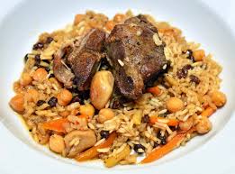
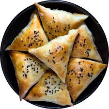
Cuisine


Map
Itineraries
| Sr. No. | Itinerary Name | File |
Our Websites